


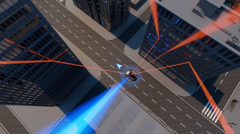
Vehicles have always needed to know where they are. But as autonomy advances, the accuracy and reliability of that knowledge becomes increasingly important. Thus, modern navigation systems do something more sophisticated than simply calculating a location. They also calculate how confident they are in that estimate. Here, Manuel Del Castillo VP of business development at GNSS software solutions specialist Focal Point Positioning, explains why this is crucial for autonomous driving in urban environments
Waymo recently announced plans to bring its robotaxi service to London, marking an important step for the UK’s emerging autonomous transportation sector. The company’s vehicles have already accumulated more than 173,000,000 miles (278,000,000km) of fully autonomous driving.
Welcoming this development, the UK government estimated that connected and automated mobility could contribute £42bn (US$56bn) to the national economy by 2035. It aims to adapt the regulatory framework to allow more driverless vehicles in UK cities in the coming years and take advantage of this economic opportunity.
But success will depend on more than new rules or more vehicles. It will depend on reliability. Autonomy must prove not just that it works, but that it consistently makes reliable decisions in tough environments. Autonomous systems must constantly decide which information they can trust.
The danger of being confident but wrong
A global navigation satellite system (GNSS) receiver produces two outputs. The first is a position estimate: latitude, longitude, altitude and time. The second is an estimate of how reliable that position is.
Autonomous vehicles rely on both pieces of information. Navigation software combines GNSS data with inputs from cameras, radar, lidar and other sensors. Each source contributes to the vehicle’s understanding of its surroundings. The system then weighs those inputs according to how reliable they appear.
The difficulty is that traditional GNSS receivers were largely designed for open environments where satellite signals travel directly from the sky to the receiver. In dense cities, the situation is very different. Signals frequently reflect off buildings before reaching the antenna, creating what’s known as multipath errors.
The receiver may still detect several satellites, and the geometry of those satellites may appear favourable. On the surface, the system looks healthy, so the receiver reports a high level of confidence in the calculated position. Yet some of the signals used to compute that position may have traveled indirect paths. The result is a position estimate that appears trustworthy but is actually unreliable due to reflections from the surrounding environment.
This ‘confident but wrong’ problem can have severe implications for automated vehicles, especially in instances where the vehicle is given control of decisions.
If a GNSS receiver reports low confidence, the system can reduce the weight it places on that input. However, if the receiver reports high confidence in a faulty estimate, the navigation stack may treat it as reliable and use it to make critical decisions.
Improving positional accuracy is therefore only part of the challenge. Improving the reliability of the confidence estimate is just as important.
New signal-processing techniques are beginning to address this issue by identifying which signals are likely to be reflections rather than direct line-of-sight signals. Once reflections are identified, the receiver can then suppress them, improving the position estimate and generating a more realistic measure of confidence. In other words, the navigation system becomes better at recognizing when its own data might be unreliable.
Autonomy depends on trustworthy positioning
Autonomous vehicles are never built around a single sensing technology. Engineers design them with overlapping systems precisely because each sensor has limitations.
Cameras provide visual context. Radar measures distance and speed. Lidar builds detailed spatial models of the surrounding environment. GNSS contributes an independent global reference that helps anchor those observations to real-world coordinates. When these independent systems agree, the vehicle gains confidence that its interpretation of the world is correct.
This type of redundancy becomes particularly valuable in urban environments where infrastructure, traffic density and tall buildings create challenging sensing conditions. Cities such as London introduce complex signal environments that place additional demands on positioning systems.
Safety naturally remains central to the deployment of autonomous vehicles. As the government noted when outlining the regulatory framework for self-driving technology, safeguards must include “protection from hacking and cyber threats.” GNSS signals, like any radio-based system, can theoretically be spoofed by transmitting counterfeit signals, which is why techniques that strengthen signal integrity and authentication are increasingly important.
For engineers designing autonomous vehicles, the goal is to ensure that the navigation system understands the quality of the information it is receiving. That distinction may sound subtle, but it is fundamental.
As automated vehicles accumulate more miles and begin operating in more complex cities, the ability to recognize uncertainty will become increasingly valuable. After all, the most dangerous navigation error is not being wrong. It is being wrong while believing you are right.