 In emergencies, every second counts. When someone is in a critical situation, emergency responders must be able to locate them as fast as possible. In vehicles, automated systems like eCall and V2X can help, but their effectiveness depends on reliable, accurate positioning, explains Jez Ellis-Gray, lead product manager at FocalPoint Positioning
An EU initiative aimed at saving lives by reducing response times to road traffic incidents, eCall, has been mandatory in newly manufactured vehicles since 2019. When a road traffic incident occurs, the eCall system immediately notifies emergency services of the location and details of the incident, potentially halving response times.
The eCall system automatically makes an emergency call if a vehicle’s sensors detect a serious collision or the system is activated manually via a call button.
Once activated, eCall instantly connects the vehicle and its driver to an operator at the closest emergency-response network and simultaneously transmits a packet of data, which includes GNSS-based location as well as information like vehicle details, number of passengers and direction of travel. eCall is predicted to save 2,500 lives per year by cutting response times by 40% in urban environments and 50% in the countryside – the benefits are clear.
A quick response
Reducing service response times is a key factor in increasing survivability in emergencies. In healthcare, reducing response times by minutes or even just seconds saves lives. For instance, in a cardiac arrest case, every minute delay cuts the chance of survival by 10% – and chances do not start at 100%. It’s no surprise then that just one in ten people survive an out-of-hospital cardiac arrest.
Seconds also count when responding to a fire. The London Fire Brigade worked for five years to shave one minute off the time it takes to leave the station after the bells sound. Fires are said to double in size every minute, so there may be just 60 seconds between a fire that can be extinguished by one crew and a blaze that requires a multi-unit response to control.
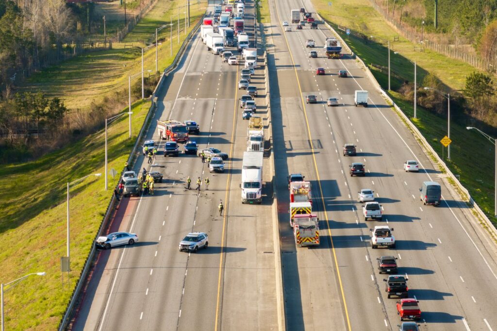
On the roads, one can imagine how eCall would benefit rural areas, where the chance of a passerby alerting emergency services after spotting an incident is lower than in built-up areas, especially at night. But even a small GNSS error in the eCall data packet could lead to significant delays, especially if a crashed vehicle is hard for emergency services to physically see.
Mixed signals
Environmental factors can impact GNSS signals and reduce the accuracy of location data. For example, tall buildings in towns and cities can create ‘urban canyons’ that prevent accurate satellite navigation and this can be made worse by multipath interference, where signals bounce off buildings. In the countryside, hills or even trees on forest roads can disrupt signals.
In one case in which a van belonging to water company Severn Trent left the road, an automatic eCall was sent out. However, the vehicle was hidden in a hedgerow, and the semi-conscious driver had to honk his horn when the emergency services arrived at the supplied coordinates so that he could be found. Had the driver been non-responsive, the lack of precise location data would have led to a longer delay and potentially a worse outcome.
On motorways, where a stranded vehicle might quickly cause further problems, accurate and precise location data is crucial for eCall. For instance, if the accident occurs on a stacked or multi-level motorway overpass and the location data is disrupted by multipath interference, services might be sent to the right area but the wrong level and face a lengthy reroute to reach the scene.
Next steps
The original eCall system uses 2G and 3G networks, which are now being phased out by service providers in favor of 4G and 5G. In response, Next Generation eCall (NG-eCall) will use the new networks and may also be able to send multimedia data, such as footage from dashcams, or control elements of the vehicle. From Jan 1 2026, all new EU vehicle type approvals must be compatible with NG-eCall.
If NG-eCall also integrates accurate GNSS, it could save even more lives. For example, software upgrades can now improve GNSS location signals by mitigating multipath interference without the need for cumbersome, costly hardware upgrades.
V2X
Further technology could enhance the response once an eCall has been made, such as vehicle-to-everything (V2X) communication. V2X enables the exchange of information between vehicles and other elements within the urban environment. When fully rolled out, V2X would allow emergency vehicles to communicate in real time with other vehicles, traffic control infrastructure and even pedestrians.
The UK has already made steps toward V2X. In 2024, South East Coast Ambulance Service became the first ambulance fleet in Europe to use digital alerting. In the fire service, Avon Fire & Rescue was the first to implement HAAS Alert, a system for alerting road users of their presence via navigation apps like Waze.
Connected ambulances and fire engines traveling to assist an eCall could trigger driver alerts, request green lights, optimize routes and coordinate with traffic control to make their journey as smooth as possible. Together, this smart communication could help emergency staff reduce their response times.
However, without reliable positioning, none of these V2X benefits can land. Both eCall and V2X technology hinge on reliable satellite location data, so one of the technical blockers is unreliable GNSS.
Solutions that boost accuracy without additional hardware or infrastructure can provide benefits without significantly increasing costs. For example, FocalPoint’s S-GNSS Auto software works at the chip level to improve the accuracy and reliability of standard GNSS receivers without hardware upgrades.
Full autonomy in vehicles may one day help prevent many crashes, but we don’t have to wait to save lives. The fastest gains come from treating positioning as safety-critical now so that eCall and V2X can find people, clear routes and cut delays. In emergencies, every second counts, and better GNSS performance helps turn those seconds into survival.
To find out more about S-GNSS Auto and the work that FocalPoint is doing to improve GNSS reliability, visit www.FocalPointPositioning.com or read an exclusive feature on GNSS in the January 2026 issue of ADAS & Autonomous Vehicle International.