
New York City Department of Transportation (NYC DOT) commissioner Mike Flynn has announced the use of Viva’s new sensors to better understand how New Yorkers use their streets and to inform safer street design.
First piloted in 2023, these small, privacy-protective smart traffic monitoring sensors count pedestrians, cyclists, buses and vehicles to assess patterns in how people use the streets. Sensors will be installed at approximately 80 additional locations across the five boroughs to accelerate data-driven street safety improvements.
“Safer street design starts with understanding what is actually happening on the street,” said Flynn. “These high-tech sensors will help us evaluate how people are walking, biking and driving so we can design safer streets and encourage safer behavior.”
Building on the successful pilot, NYC DOT will this year scale up a technology that has already transformed how the agency measures traffic activity. Initially installed at 20 locations, the sensors replaced traditional manual traffic counts with continuous, real-time data collection – providing a far more comprehensive picture of how pedestrians, cyclists and vehicles move through city streets.
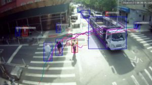
Mounted on NYC DOT street infrastructure, the sensors anonymously analyze street activity. In addition to counting different types of road users, sensors can measure speeds, capture turning movements and map how different users move. For example, the sensors could identify areas where pedestrians are crossing mid-block instead of at crosswalks. This could help identify locations where a mid-block crosswalk would be beneficial.
Traditional planning methods have previously relied on short-term, labor-intensive counts. The sensors operate continuously, capturing changes in travel patterns by time of day, season and street design. Designed with privacy as a core value, video footage is processed in real time and immediately discarded, with only anonymous data retained. Faces and license plates are deliberately obscured in any video footage.
By analyzing detailed data on how streets are used, the agency plans to use the sensors to evaluate the effectiveness of street redesigns and safety projects, identify high-risk locations before crashes occur through near-miss analysis, better allocate street space among pedestrians, cyclists and vehicles, improve access to transit, loading zones and local businesses and build a dataset to track changes in pedestrian and cycling activity across the city over time.
The sensors will be installed in a diverse range of corridors – from busy commercial streets to residential neighborhoods, ensuring that sensor data reflects the full complexity of New York City’s transportation network.
In recent news, Madrid marks latest milestone in WeRide-Uber robotaxi partnership